
Arthur’s Pass is one of the most scenic routes in New Zealand. Whether you travel by road or by rail, the views are breathtaking—tussock-covered peaks towering above sweeping valley floors, deep river gorges, and lush West Coast rainforest.
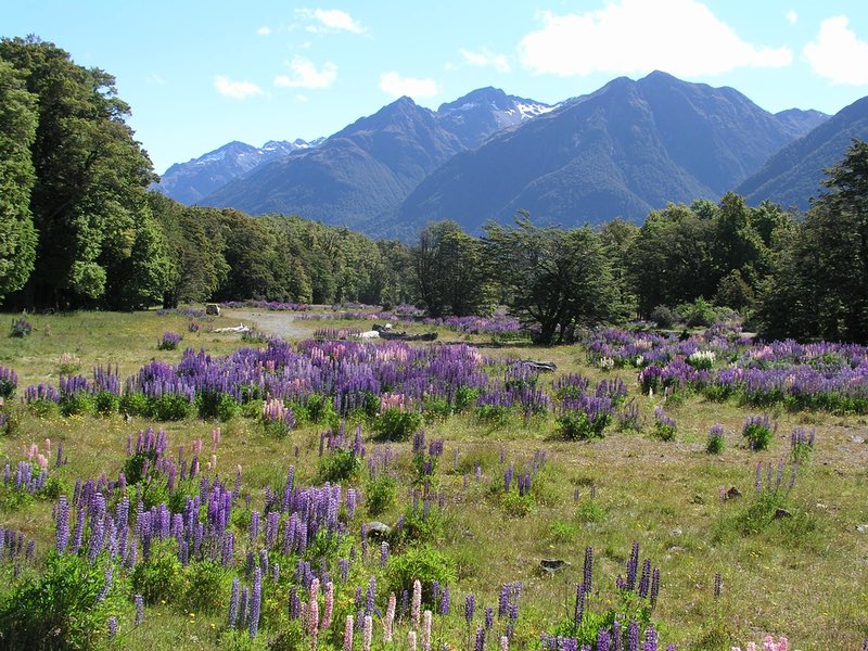
Image by NT Franklin from Pixabay
Arthur’s Pass Highway
The TranzAlpine Train through Arthur’s Pass is often called one of the world’s great rail journeys. My advice? Skip the train and drive through the pass instead. If you take the TranzAlpine Train, you miss out on some of the true highlights of this spectacular route: Castle Hill, Cave Stream, and Inquisitive keas (New Zealand’s mountain parrots).
 The Arthur’s Pass Highway forms a crucial link between Christchurch and the West Coast, which means most travelers making a loop around the South Island will end up crossing through the Southern Alps here. There are very few roads cutting from east to west through the South Island’s mountainous spine, and of the three major passes, Arthur’s Pass packs the most drama and excitement along the way.
I’ve had many opportunities to drive the Arthur’s Pass Highway—while I lived in Christchurch, it was always the first place I took visitors. The journey from east to west gives a perfect overview of the South Island, from the rolling Canterbury Plains to the pounding West Coast seas. This is New Zealand in miniature: civilization and cultivating butting up against untouched wilderness; mighty rivers shaping both landscapes and lives; and scenery changing around every bend.
While the drive from Christchurch to Hokitika takes less than four hours, you’ll easily fill an entire day exploring Arthur’s Pass, so be sure to get an early start. There are limited lunch options at Arthur’s Pass Village; you may want to pack a picnic if you plan to spend several hours exploring Castle Hill and Cave Stream.
Leaving Christchurch
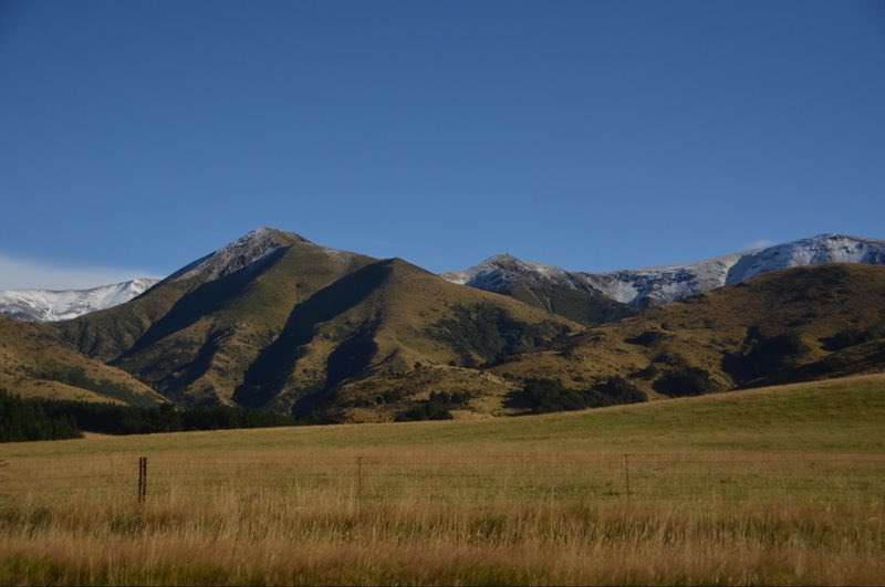
As you leave Christchurch behind, the city gives way to suburbs and lifestyle blocks and then to picturesque farmland. Sheep graze in lush fields, and the foothills of the Southern Alps rise in the distance.
The landscape grows steeper and wilder as you reach the first hills of the Southern Alps. The road follows the Waimakariri River up to the foothills, where pastures give way to rolling tussock-lands.
Approaching the foothills of the Southern Alps
Lake Lyndon
After climbing through narrow valleys and around steep slopes, the land opens out. The road passes through a vast, flat valley floor carved by glaciers long ago, the river sprawled across its stony bed in shimmering braids. All around, mountains tower above the valley, some eroding in great colorful rockslides, others swathed in golden tussocks. The road passes by the still waters of Lake Lyndon, tucked in a valley ringed by mountains, and before long, odd rock formations begin dotting the nearby hillsides. Keep an eye out for the sign on your left pointing toward Castle Hill, where towering rocks dominate the landscape.
Castle Hill
Castle Hill is a delightful natural playground. Weathered limestone tors crown the hills like castles and battlements, giving the place its name, and many are easy to scramble up. From the top, sweeping views open out to the mountains and valleys all around. There are bolted climbing routes at Castle Hill for those who enjoy a bit more of a challenge, and children are often seen running about playing hide-and-seek among the rocks.
The Dalai Lama was so taken by Castle Hill that he once called it a “spiritual center of the universe.” And the majesty of these towering monoliths rising before a backdrop of soaring mountain peaks is hard to deny.
When the time comes to leave Castle Hill, it’s a short downhill walk back to your car, and just a few minutes’ drive to the next highlight: Cave Stream.
Cave Stream
The small sign for Cave Stream is easy to miss, as is the turnoff, which springs up on you as the road rounds a corner. If you miss the pullout, it’s worth turning back.
Cave Stream is only accessible when the rivers are not swollen, which means looking at weather forecasts for the mountains upstream as well; if possible, plan your drive through Arthur’s Pass for a warm, sunny day. The walk through Cave Stream is suitable for fit, adventurous travelers only, though others may wish to read the information panels in the parking lot.
From the turnoff, it’s hard to tell what lies below—the parking area sits atop an unremarkable tussock-covered hill with a stream wrapping around its base. Two paths lead down to the cave; take the one on your right-hand side for easier access.
After a steep scramble down to the stream, a cave mouth opens in the hillside. This is a completely natural, unaltered cave (aside from a few ladder rungs leading out through the exit), so you’ll need to bring a light.
The water is deepest at the entrance, nearly up to my chest, and as I forge into the darkness each time, I wonder if I’ll be swimming soon. It’s shockingly chilly, but once I get used to it, the water loses its bite. A few steps in, the cave narrows and grows shallower—closer to knee-deep—and this is where it remains for the rest of the journey.
It takes about thirty minutes to walk through the narrow limestone gullet of Cave Stream, splashing up small waterfalls and through deeper pools, headlamp illuminating the smooth stone walls bit by bit.
If you’re lucky, you might even encounter New Zealand’s remarkable longfin eels. On one visit, I stumbled across a pool with half a dozen young eels wriggling about, each slightly thicker than my thumb. These unique creatures spend most of their lives in freshwater before heading out to sea, where they travel thousands of kilometers to spawn near Tonga. The longfin eels are remarkably long-lived; some have been recorded at over 100 years of age.
The roaring of a waterfall signals the end of Cave Stream, followed by the first pale light. A few metal steps bolted into the cave wall skirt around and over the waterfall, and suddenly the cave gives way to an ordinary stream. From here, there is very little sign of the remarkable hidden world just steps away.
By the time I make the traverse through Cave Stream, I’m usually worn out and ready for lunch. Thankfully, the next stop is Arthur’s Pass Village, where a couple of basic cafes offer lunch and a warming drink.
Arthur’s Pass Village
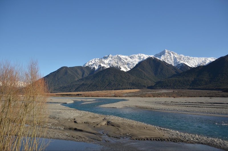
The braided Waimakariri River
The drive between Cave Stream and Arthur’s Pass Village reveals the most breathtaking views yet. The mountains are taller than ever, some peaks still clinging to patches of snow even in summer, and native beech forest swathes the lower slopes of these giants. The road follows the banks of the Waimakariri River once more, and in early summer, bright purple lupins add a splash of color to its banks.
While you linger over lunch, the local keas may pay you a visit, if you’re lucky. Keas are large green mountain parrots with a vivid red swatch beneath their wings; though far less famous than kiwis, they are one of New Zealand’s most charismatic natives. Keas are one of the smartest birds in the world, and one of their favorite pastimes is getting up to mischief, so keep a close eye on your food—and your car. They enjoy pecking at the rubber lining around car windows, and their wickedly sharp beaks can cause serious damage. One tactic they enjoy is working in pairs—while one kea jumps around and poses for photos, the other sneaks off to cause trouble.
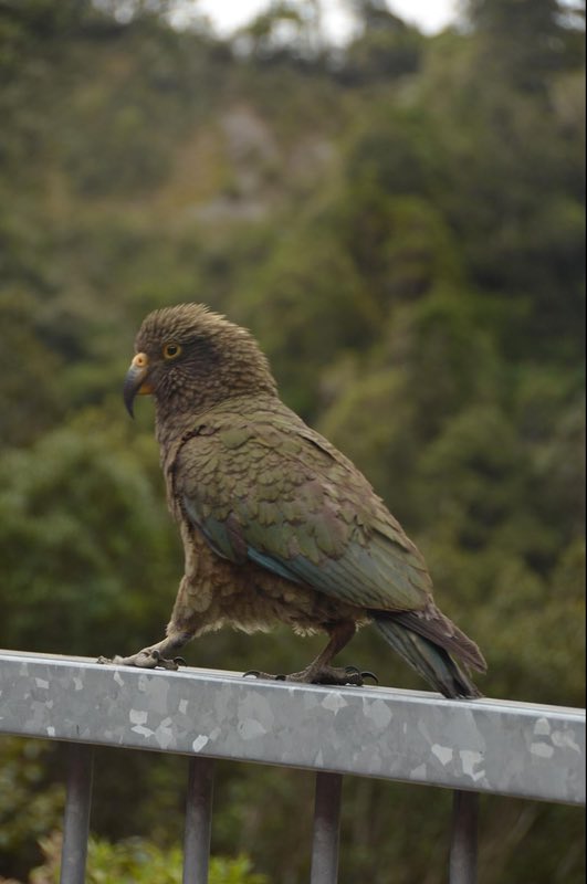
A kea showing off at Death’s Corner
These beautiful birds are now endangered, with only a few thousand remaining, so it’s a treat to see them in the wild. Arthur’s Pass is one of the most reliable places to find them.
Visitor Center
After lunch, you may want to pay a visit to the Department of Conservation visitor center in Arthur’s Pass Village, which has informational displays on local wildlife as well as a large 3D map of the nearby mountains. There are also countless hikes in the area, from the short walk to Bridal Veil Falls to the grueling climb up Avalanche Peak.
Looking over Arthur’s Pass Highway from the Avalanche Peak Track
Main Divide
Just past Arthur’s Pass Village, the road reaches its highest point, the Main Divide between east and west. A sign marks the turnoff to Death’s Corner, a breathtaking lookout over the plunging West Coast valley ahead. This is another likely place to find keas.
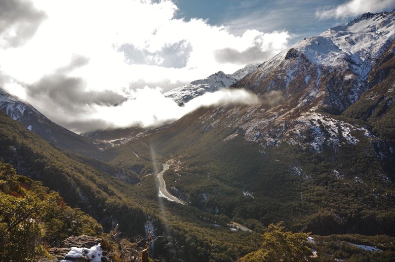
Up until this point, it doesn’t feel as though the road has gained much elevation since most of it passes through flat valley floors. But from here, the descent is sudden and dramatic.
The Main Divide on the South Island runs down the spine of the Southern Alps. All water that falls west of the divide flows to the Tasman Sea, and all water east of the divide drains to the Pacific Ocean.
This is also where the rain shadow begins. The east side of the divide, where you have just traveled from, is much drier than the west. The mountains are covered in tussocks rather than trees, and the Canterbury Plains are mostly open pastureland.
When the road crosses to the west side of the Main Divide, the contrast is stark. Instead of golden tussocks, the mountains are covered in dense temperate rainforest, a tangle of verdant trees and moss and undergrowth.
The West Coast forests are the result of frequent, drenching rainfalls that deposit more than ten meters per year in places. And it’s not just the forests that have been shaped by the wild West Coast weather. Civilization is sparse all along the coast—the total population is just over 32,000—and residents are constantly dealing with landslides and washed-out bridges that cut off whole towns for days at a time. Where land is abandoned, it is quickly reclaimed by the every-hungry wilderness.
A vivid example is Charleston, which was a gold mining boomtown in the 1860s, with 5,000 residents at its peak. Nothing remains now except a handful of houses. All evidence of the once-bustling mining town is gone, overcome by rata and kamahi and beech.
West Coast
The raw wilderness of the West Coast is evident as you begin the descent. The road hugs a near-vertical cliffside, the Otira River cascading over loose stones far below. From the Otira Viaduct lookout, you can see where the road crosses the river on a towering bridge. At one point, cars pass beneath a chute that channels a waterfall over the road to avoid flooding and rockslides—both a common occurrence.
Here, the road offers much better views than the train. Rather than following the road through this gorge, the TranzAlpine Train enters a long tunnel, so passengers miss the dramatic, dizzying initial descent.
Eventually, the road flattens out, though the mountains on either side remain as steep as ever, ridge after ridge swathed in brilliant green. Finally, you reach a fork in the road, and ahead lies the coast, the seas rough and the beaches rocky. Even the ocean is raw and untamed here on the West Coast, and the sliver of cultivated land clings to the narrow margin between towering peaks and pounding surf.
The journey through Arthur’s Pass is over, but there is still much to discover on the West Coast, where wilderness rules supreme. And beyond, the rest of New Zealand beckons.
 New Zealand Lord of the Rings Locations – A Visit to Middle Earth
 Zorbing – Riding a Human Hamster Ball – Rotorua, New Zealand
 Black Water Rafting in the Waitomo Caves – New Zealand
 Maori Culture on New Zealand – Video Episode 63
by Rebecca Vickers
Rebecca is a content writer for the New Zealand Travel Organiser group. She came to New Zealand on a working holiday seven years ago and never left; in the meantime, she has explored both islands extensively, combining the excitement of a first-time visitor with the insider knowledge of a local.5 Responses to “Christchurch to Arthur’s Pass Drive – New Zealand in Miniature”
Leave a Reply
Tags: article, new zealand, south island


Steve P
Says:January 27th, 2020 at 11:01 am
I just read Rebecca’s article. It is excellent. We really enjoyed our trip there.
A couple of thoughts about the article. I recommend both the car trip and the Tranz Alpine train if you have the time. They go through different parts of the landscape and both are beautiful.
You still need to plan carefully going to Christchurch as they are still rebuilding the earthquake damage and sometimes roads and buildings are blocked off. They have several sites that can help with your plans.
Keith Lim
Says:January 30th, 2020 at 7:15 pm
Outstanding article! Really brave go suggest skipping the train ride but I can see that is worth it. The scenery is stunning and highlights the natural beauty of New Zealand, one of my favourite countries to visit! I remember my road trip in north island well, and now it’s time to plan one in the south. Certainly adding Arthur’s Pass into the itinerary!
Nitish
Says:January 31st, 2020 at 3:15 am
I read and really enjoyed reading this post. New Zealand is a scenic place one can visit. I would love to visit this place.
Sunil
Says:May 10th, 2024 at 2:40 am
I thoroughly enjoyed reading this post and found it to be quite engaging. New Zealand is a picturesque destination that I am eager to explore in person.
Jyoti
Says:August 8th, 2024 at 11:06 pm
I read the article & I really like it. From rolling plains to snow-capped peaks, this journey offers a breathtaking panorama that’s hard to beat. The journey is a breathtaking display of nature’s artistry. A must-do for any adventure seeker!