I like to think I’m in fairly good shape. I exercise regularly and other than stove-top popcorn I’m pretty much a healthy eater. I wouldn’t call myself an avid trekker (because carrying a weighty backpack really ruins the scenery, in my opinion) but I do enjoy hiking, camping, and pretending I can rock climb. So I was pretty pumped to be traveling to Huaraz, Peru’s mecca for outdoor enthusiasts. But Hiking in Peru is not the same as hiking at home.
The city of Huaraz sits over 10,100 feet above sea level. It is relevant to note that altitude sickness for weak lowlanders kicks in at about 8,000 feet. I’m from Ohio, a state that has an unimpressive altitude of 550 feet. I think you can guess how I dealt with the altitude (hint: not very well).
The Town of Huaraz
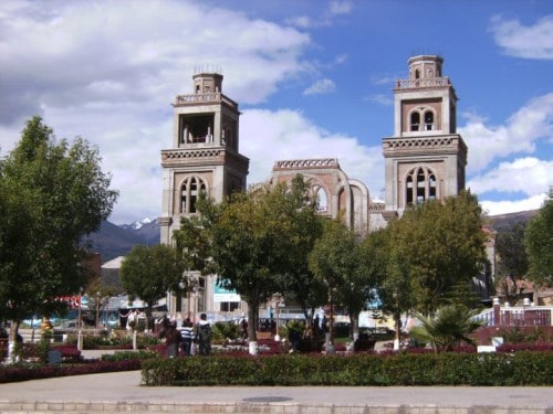
Huaraz is a surprisingly dingy place (most Peruvian cities are tidy affairs), but hidden in the grunge are some remarkable cafes catering to backpackers and hard-core mountain climbers. I slightly fell in love with Café Andino, the ultimate expat hangout. They serve delicious breakfasts, smoothies, and burritos (which are difficult to find in Peru) all at a decent price. Plus they have an extensive library of books available to borrow. California Café, a few blocks away, is another gem.
The Mountains
So what are these hip international-style hangouts doing in this dusty town? It’s all about the mountains. Huaraz is smack in the middle of the Cordillera Blanca and the Cordillera Negra, two massive mountain ranges that are part of the Andes. The Blanca range is about 12.5 miles wide and 112 miles long and has more than 30 peaks that top 18,400 feet. To put that in perspective, all of North America has only 3 peaks that tall (Mt. McKinley in Alaska, Mt. Logan in Canada, and Volcan Citlaltépetl in Mexico). This consolidation of sky-high peaks with base camps easily reached from town is what makes Huaraz so hip.
But let’s get one thing straight: I’m no mountain climber. I don’t “do” base camp. I don’t own crampons. The idea of carrying all my gear on my back as I forge through snow and ice and possible death doesn’t fit my definition of a good time. So for me, these mountains were simply a beautiful backdrop.
However, I did venture out on one excursion. Laguna 69 is a long day hike (with a giggle-worth name) that starts at 12,465 feet and ascends to 15,090 feet—higher than the highest mountain in the continental USA.
Hiking to Laguna 69
The adventure to Laguna 69 requires hiring a taxi to drive you 3 hours to the trailhead, passing two twin turquoise lakes of Llanganuco (Chinancocha and Urconcocha) along the way. I paid 180 soles for round trip transportation, not a bad price if it is split among a few people. A guide isn’t necessary, because the trail is easy to follow, but be sure to have 5 soles for the one-day entrance fee for Huascarán National Park, where the lake is located.
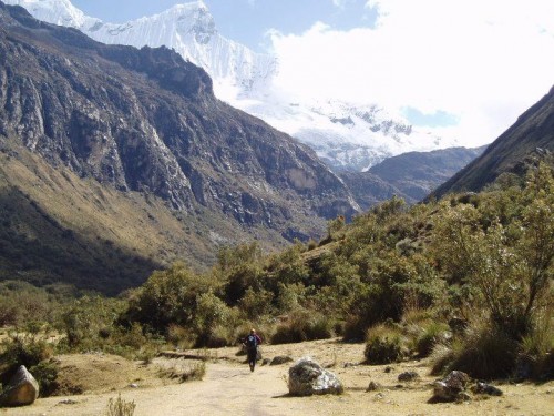
The first portion of the trail crosses a fairly flat valley. What should have been an easy stroll left me panting and light-headed after 15 minutes. The altitude and I were not friends. The bad news is that each step felt like I was pushing through an invisible wall of Jell-O. The good news is that because the easy part was so difficult, by the time I hit the incline I was almost immune to the agony. I staggered along like a drunken soldier—sloppy but determined—while other hikers zoomed past with their walking poles, trendy trekking gear, and an apparent abundance of oxygen.
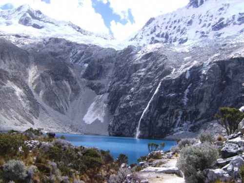
I preemptively celebrated summit victory at a tiny lake at the top of the first pass, only to discover it was not Laguna 69; I still had miles to go. This was a momentary mental setback, but 4 hours after stepping out of the taxi, I finally arrived at the sparking little lake surrounded by glaciers and icy peaks. Laguna 69 is pretty enough by itself, but I’m pretty sure the ridiculous effort required to reach its shores had something to do with its splendor.
With fears I wouldn’t make it back before dark, I only spent about 40 minutes appreciating the magnificent beauty of Laguna 69—listening to cleaving glaciers and watching bits of ice tumble down—before beginning the speedier but still difficult decline back to base (it took me 2 and a half hours).
- Get an eSim to be able to use your smartphone abroad.
- Get a universal plug adapter
- Get a Car Rental
- Search for Great Tours HERE
- Buy Travel Insurance
- Book Your Accommodation HERE
Get There
Huaraz is easily reached from Lima, Peru’s capital and the only city with an international airport. Frequent buses run between the two cities, and a one-way journey takes about 8 hours. Expect some spectacular scenery and a lot of windy roads. I recommend the bus companies Movil Tours and Cruz del Sur for their safety records and fairly comfortable reclining seats. For the best views, book tickets in the first row of the second level. If you get motion sickness, stick to the first level.

 Could Marcahuamachuco, Peru Really Rival Machu Picchu?
 Planning a Trip to Machu Picchu, Peru For First Timers
 Trekking in Ecuador’s Quilotoa Loop – Episode 392
 Chicha: The Infamous Saliva-Fermented Beer From Peru

David Elwood
Says:October 20th, 2011 at 5:07 am
Great post. Thanks a lot for the description of a place I never heard of, but must put on my list.
Paul Jones
Says:March 15th, 2013 at 10:03 am
Great article, and some really great photos.
Rich
Says:January 22nd, 2016 at 3:35 pm
Hi Laura
Just was researching for my Peru trip coming up in a few days. I too suffered from altitude sickness, at least as a child so I’m a little concerned about spending time in Cusco as my friends have recommended.
Not sure if you’ve been there but as a fellow vangabond, I wanted to recommend the Cocora Valley in Colombia. you can check out my photos there. Much lower elevation too!
Stephan Nasstrom
Says:February 12th, 2016 at 12:29 pm
Very interesting.
I’ve been to Peru about 30 times since 1978 been to Trujillo 15 times, Piura once, Paraacas, Cusco and Machu Picchu once.
Would love to go to Huaraz because I love mountains. Probelm is the altitude. In Cusco I stayed at the Monasterio luxury hotel where you 50 dollars for oxygen per night.
Maybe I’ll go to Huaraz for a day or two only.
Best regards, Stephan, Stockholm, Sweden.
Retired journalist. I live in Lima three, four months, sometimes six seven months, a year.